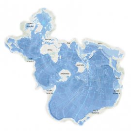
[intro music] Welcome to World Ocean Radio… I’m Peter Neill, Director of the World Ocean Observatory. How to change the way we see the world? We have been schooled to visualize and understand our global arrangement by maps and projections, specifically the Mercator projection that aligns the hemispheres, west and east, in a relationship that has informed our relations, conflicts, and cultures as apposite, often opposite. On the surface, it appears a balanced view, a terrestrial equilibrium, that affirms land mass as its focus, surrounded by an indifferent sea. That world view was challenged when, in 1972, a photograph of Earth from space, taken by the Apollo 17 space mission, revealed our planet as fragile entity in a cosmic ocean, a blue marble, mostly water, protected by a wafer-thin layer of atmosphere, itself vulnerable, primarily from anthropomorphic action from within. It was both an exhilarating and humbling worldview, that fostered, partially, a sense of stewardship of something so precious and not to be corrupted or destroyed. We suddenly saw ourselves, not as a balance of power, but as an entirety of Nature. Visualization, then, is a powerful tool for understanding, beyond data, that enables transformative perspection and opens our minds and conventions to question. As a new paradigm for survival in the 21st century, I have been promoting the idea of “hydraulic society,” a world organized around the value of the ocean, our living hydrospace where water and all its integrated nurturing elements must be the core of our future values, structures, and behaviors, the focus around which we invent and prioritize actions for the future. It has proved a difficult argument, one reason being that is hard to visualize. In 1936, Athelstan Frederick Spilhaus, a South African geophysicist and oceanographer, immigrated to the United States, and joined the Woods Hole Oceanographic Institute in Massachusetts where he developed the bathythermograph, a tool enabling measurement of ocean depths and temperatures from moving vessels, a breakthrough in ocean science and in submarine warfare. Spilhaus, who died in 1998, had a fascinating mind and career. He first proposed the idea of sea grant colleges, as a balance to the land grant charters that characterize many American state universities, the concept that underlies the Sea Grant Programs that train students and support programs in ocean science to this day. He was an iconoclast communicator; he was on the Science Advisory Board of the American Newspaper Publishers Association, and, from 1957 to 1973, he created “Our New Age,” a Sunday cartoon feature for science literacy that appeared in the color comic section of some ninety-three American newspapers. He exposed millions of readers to science and the ocean, but remains mostly unknown. One of his most brilliant accomplishments, developed in 1979 with Robert Hansen and Erwin Schmid, was what has become known as the Spilhaus World Ocean Map, a new projection of earth centered on Antarctica that projects the ocean as the central focus of a new astonishing worldview, pushing the land to the outer edges of the square, thus re-organizing our global geography around the true natural systems of the world ocean, across which nations are organized and connected. It is a startling revelation, a revolutionary perception comparable in power to the Mercator or Blue Marble visualizations, especially in this time when we must re-imagine our future challenged by climate consequence, including pandemic, afflicted by past behavior on land. A new paradigm for survival requires a new way of seeing the world. And the Spilhuas projection enables a vision for that change. It prioritizes elements of a new ethos and value proposition; it becomes a framework for planning, policy, and performance. In my book, The Once and Future Ocean, published in 2016, I put it this way: “If we can envision the ocean as beginning at the mountain-top and descending to the abyssal plain, if we can relate to water as an organizing principle for how we live in and on the land, then we can understand the protection of its integrity free-flowing and pure, in relation to the most important requirements for successful living. We can understand the ocean as a system of literal and social unification, if we apply that premise, then we affirm the efficiency of the nature system to determine different patterns of settlement, preserve clean water for human consumption and agriculture, generate alternative energy, protect us from extreme weather and sea level rise, provide spawning ground for marine species, and offer the solace and peace that being by the water seems universally to inspire.” We will discuss these issues, and more, in future editions of World Ocean Radio. [intro music]